
Network map
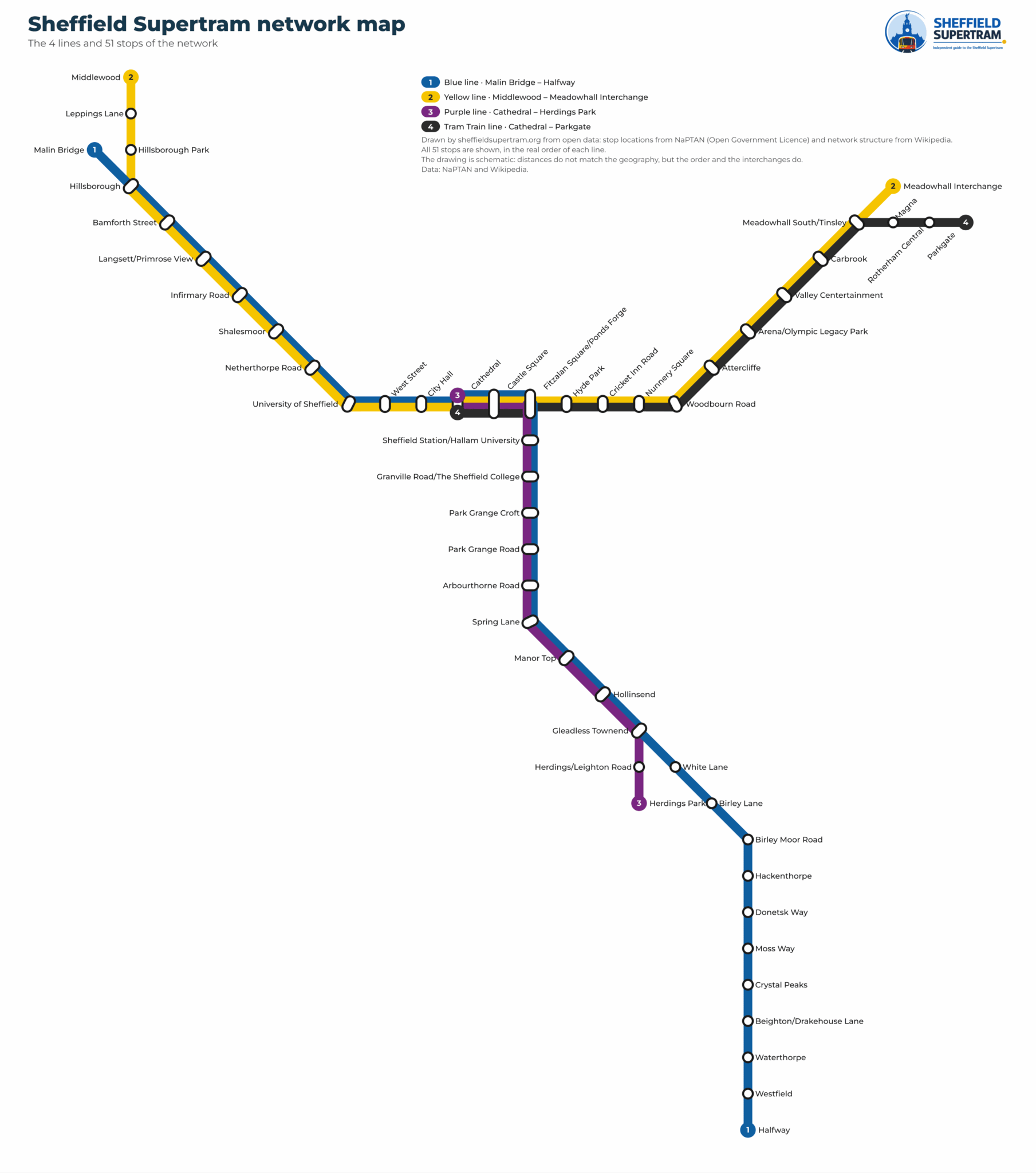
The eight Supertram lines and their 51 stations on one map, also as a PDF
The network map
 Enlarge
Network map as a PDF
Vector and sharp at any size, even printed at A3.
What the map shows
The map shows all four lines — which stations they serve, the order they come in, the colour of each line and where it runs. The coordinates of the 51 stations come from open data, and that is what underpins it.
What it shows first is that the lines all run through central Sheffield, meeting at Cathedral, Castle Square and Fitzalan Square, and then spread out across the city — west to Malin Bridge, north to Middlewood, south to Halfway and Herdings Park, and out to Rotherham on the Tram-Train.
| Line | Route | Stations | Length | Shared stations |
|---|---|---|---|---|
| 1 | Malin Bridge – Halfway | 33 | 17,81 km | 21 |
| 2 | Middlewood – Meadowhall Interchange | 25 | 12,54 km | 21 |
| 3 | Cathedral – Herdings Park | 14 | 7,19 km | 12 |
| 4 | Cathedral – Parkgate | 15 | 11,22 km | 12 |
Every station by line
In order, terminus to terminus. Tap a station for its times and what is nearby.
Malin Bridge – Halfway
33 stations · 17,8 km · 59 minutes end to end
Middlewood – Meadowhall Interchange
25 stations · 12,5 km · 42 minutes end to end
Cathedral – Herdings Park
14 stations · 7,2 km · 24 minutes end to end
Cathedral – Parkgate
15 stations · 11,2 km · 37 minutes end to end
Frequently asked questions about the network map
Yes. The PDF above is vector: it stays sharp at any size, even printed at A3.
The map and the data underneath are credited on the sources and licences page, which says how you may reuse them.
Because the network reaches beyond Sheffield: 3 of the 51 stops are beyond the city, out to Rotherham on the Tram-Train.
In the city centre, at Cathedral, Castle Square and Fitzalan Square/Ponds Forge, where the lines meet and you step across to the next one.